
Cart (
0
)
No items found.
Go to pricingProduct is not available in this quantity.
Upload a laser scan of a forest from a drone, terrestrial or handheld scanner. PointLab detects individual trees and measures the height, diameter at breast height (DBH), crown and approximate wood volume of each one. You get a tree list, volume per hectare and a stand map — in your browser, with no installation.
Free for everyone until 30 November 2026 — a trial period before the official launch.
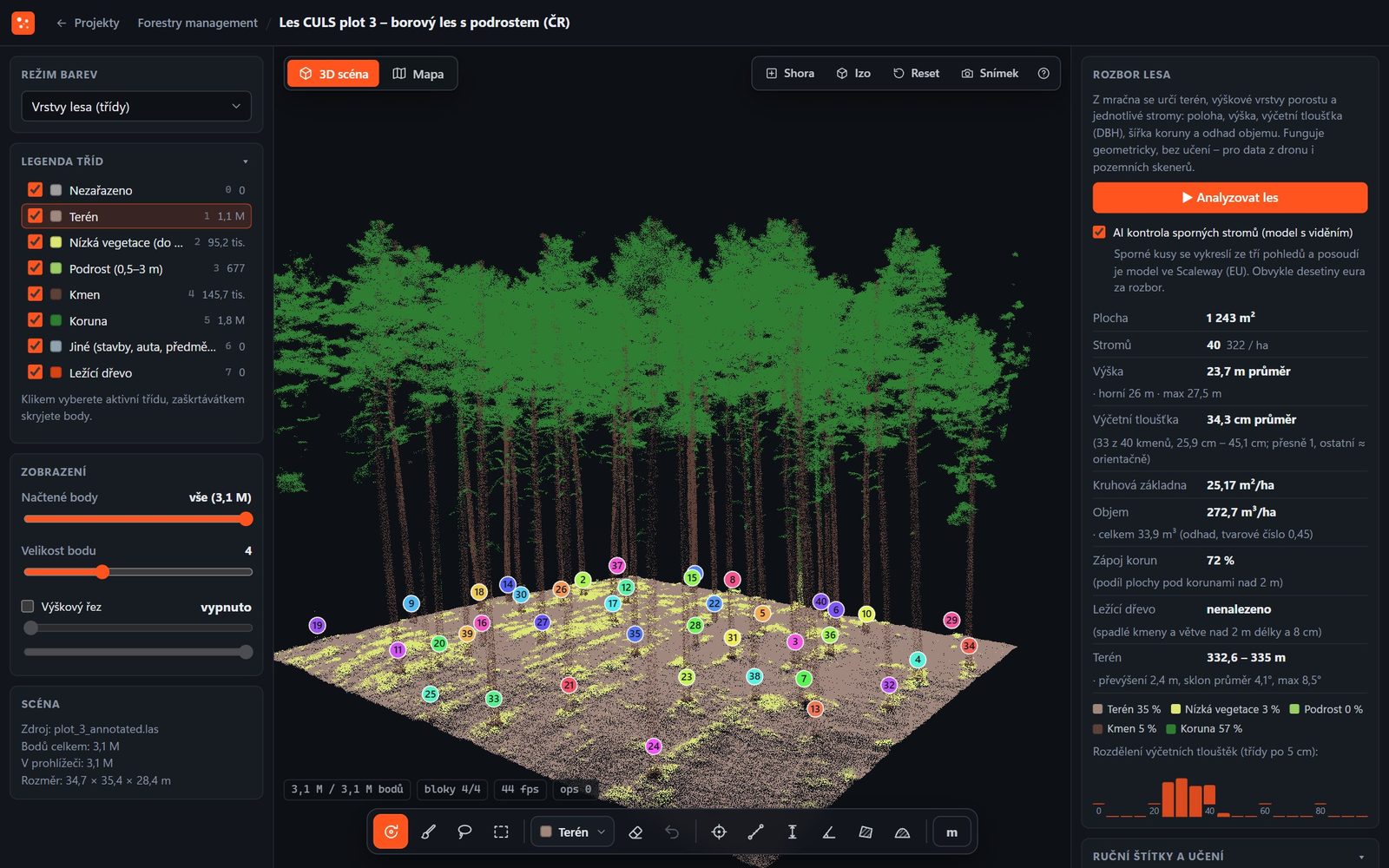
Vegetation layers: terrain, low vegetation, understorey, stems and crowns. On the right, a stand summary with height, DBH and volume per hectare. Data: FOR-instance (CULS, Czech Republic), CC BY 4.0.
The analysis is geometric and needs no prior training — for drone data as well as terrestrial scanners. Each tree gets its own number and colour.
Trees are detected from stems and crown tops, including suppressed trees under the canopy. The stem follows the tree axis, even for leaning and curved stems.
The height of every tree and the diameter at breast height (DBH) from a circle fitted at 1.3 m. Each diameter shows its quality — accurate, approximate or not measured. Nothing is guessed.
Crown diameter and crown base height, basal area and approximate tree volume. The tree list can be sorted and searched; a click zooms to the tree in the scene.
Trees per hectare, mean, top and maximum height, a DBH histogram in 5 cm classes, basal area in m²/ha and volume in m³/ha and in total. Plus canopy cover and terrain slope.
Fallen stems and large branches from 2 m in length and 8 cm in diameter — with length, diameter and volume, in the scene and on the map.
Terrain, low vegetation up to 0.5 m, understorey 0.5–3 m, stems, crowns and downed wood. Buildings and cars among the trees go into a separate class and don't distort the result.
A scan with RTK positioning is placed on the map over the ČÚZK orthophoto — with crowns, tree numbers and downed wood. Works with S-JTSK as well as coordinates in degrees; a mirrored RTK export can be fixed directly on the map. See all your company's forests on one stand map.
Contour lines at intervals from 0.25 to 10 m or a custom interval, every fifth one an index contour with elevation. Download them as DXF for CAD or GeoJSON for GIS.
CSV of trees and downed wood with coordinates and GPS, GPX for navigating to trees in the field, GeoJSON for GIS, LAZ with classes and tree number, E57 and DXF contour lines.
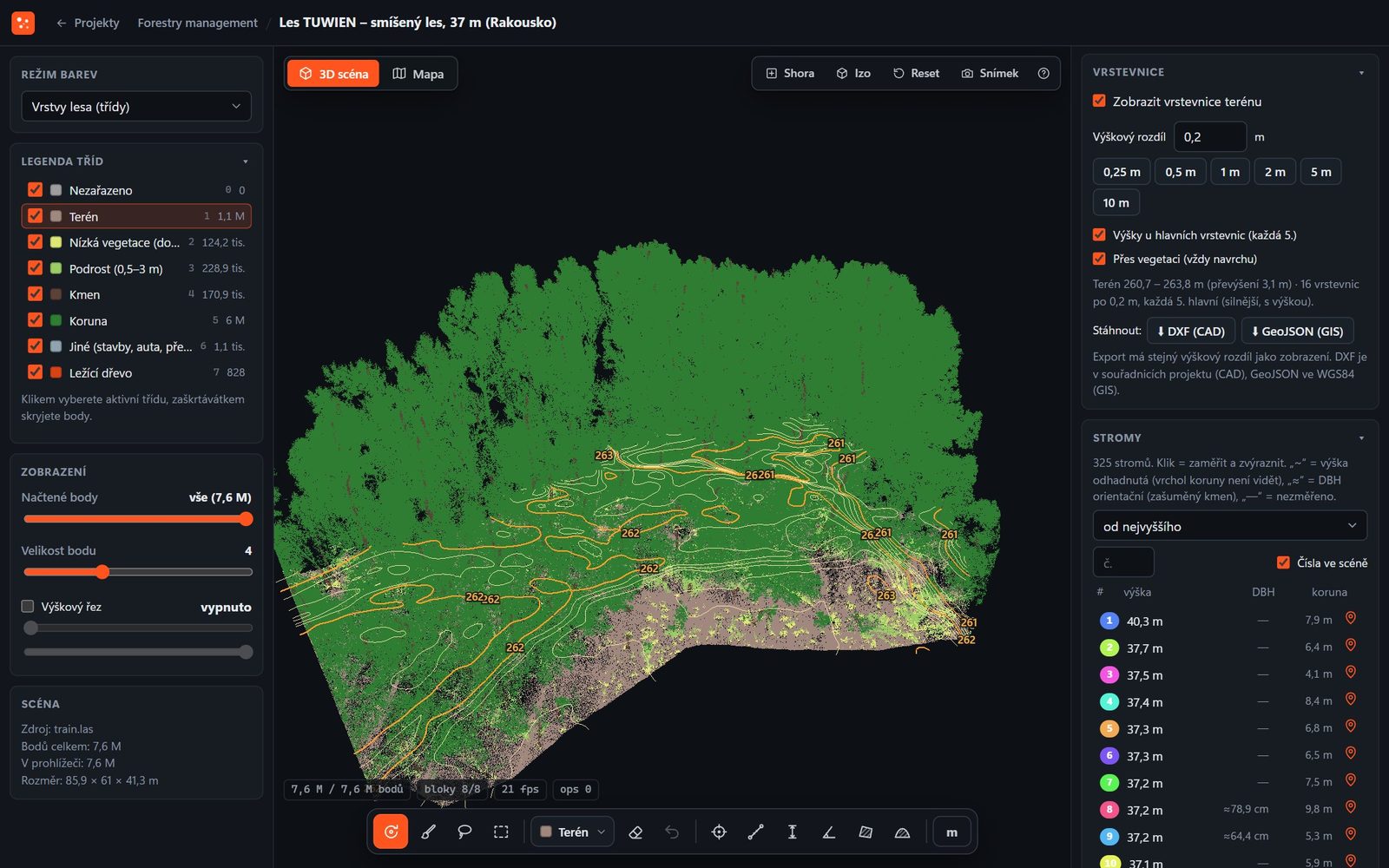
Terrain contour lines and a tree list with height, DBH and crown. Data: FOR-instance (TU Wien, Austria), CC BY 4.0.
These figures are test results on publicly available reference plots with hand-labelled ground truth, not estimates. On your data, they vary with the scan type and point density.
of trees detected on six reference plots, depending on stand type
crown agreement with a hand-labelled reference (IoU)
terrain model accuracy (RMSE)
DBH deviation (RMSE, 18 trees, CULS plot)
FOR-instance dataset — six drone laser scanning plots (Czech Republic, Norway, New Zealand, Australia, Austria). Terrestrial and mobile scans give the most accurate diameters.
All you need is a point cloud in LAS, LAZ, E57 or PLY format from a drone, terrestrial, mobile or handheld scanner, with files up to 20 GB. Terrestrial and mobile scans give the most accurate stem diameters.
On the CULS reference plot, the deviation was 5.0 cm (RMSE, 18 trees). Every diameter comes with its quality — accurate, approximate or not measured — so you know which figures to trust.
Remove a wrongly detected tree with the eraser in one click; the correction also applies to later analyses and can be undone. The system learns from manual labels and finds them on its own next time. Optionally, disputed trees can be checked by an AI vision model operated in the EU.
Yes, the module also measures trees in parks and avenues. For a whole street with lights, signs and street furniture, use the Corridors and mapping module.
The results are technical data for forest and tree inventories. They are not an official output of surveying activities under Czech Act No. 200/1994 Coll.
Data and processing run in the cloud in the EU (Scaleway, Warsaw). Only your company can see your projects and results.
Power line protection zones, railway clearance gauges, road slopes and road asset inventory.
Corridors and mapping →Building point cloud classification for scan to BIM, machine layouts and IFC models.
Buildings and interiors →Textured 3D model, orthophoto and DSM from drone photos with an accuracy report.
Drone photogrammetry →All four modules, storage-based plans and verified accuracy in one place.
4CAD PointLab →We offer 3D scanning services in the Czech Republic, Slovakia, Poland, Austria and Germany. We come on site, capture the data you need and use PointLab to prepare the output you need — a classified point cloud, a floor plan, a forest inventory, a power line inventory or a drone model. No need to buy a scanner or software.
Tell us the location, scope and output you need — we'll get back to you within 24–48 hours. More about the service on our Forest scanning services page.
We will be happy to advise you and call you back.
Leave us your contact details and our sales representative will get in touch as soon as possible to explain everything in detail.
PointLab is free for all users until 30 November 2026 — a trial period before the official launch. The plans below apply from 1 December 2026.
All plans include all four modules. The plan sets the storage for uploaded data and the number of users; additional users can be purchased.
As a guide: 1 GB of LAZ corresponds to roughly 25–40 million points, a 20-minute handheld scan takes 0.5–1.5 GB and a drone scan of one hectare of forest 0.2–0.5 GB. Tell us what data you work with and we'll prepare a quote.
Create your account and upload your own point cloud or drone photos. Want to go through the results with us? Book a demo.
Lukáš Tisoň · 3D scanner sales · +420 735 084 982 · lukas.tison@4-cad.cz
Don't have your own scanner? We'll scan it for you — Czech Republic, Slovakia, Poland, Austria, Germany