
Cart (
0
)
No items found.
Go to pricingProduct is not available in this quantity.
After an as-built survey of a building or production hall, you have millions of points. PointLab sorts them into structures, openings, equipment and machines, so you send a point cloud split by class to your BIM and CAD software. Move machines together with their points and see collisions and clearances right away.
Free for everyone until 30 November 2026 — a trial period before the official launch.
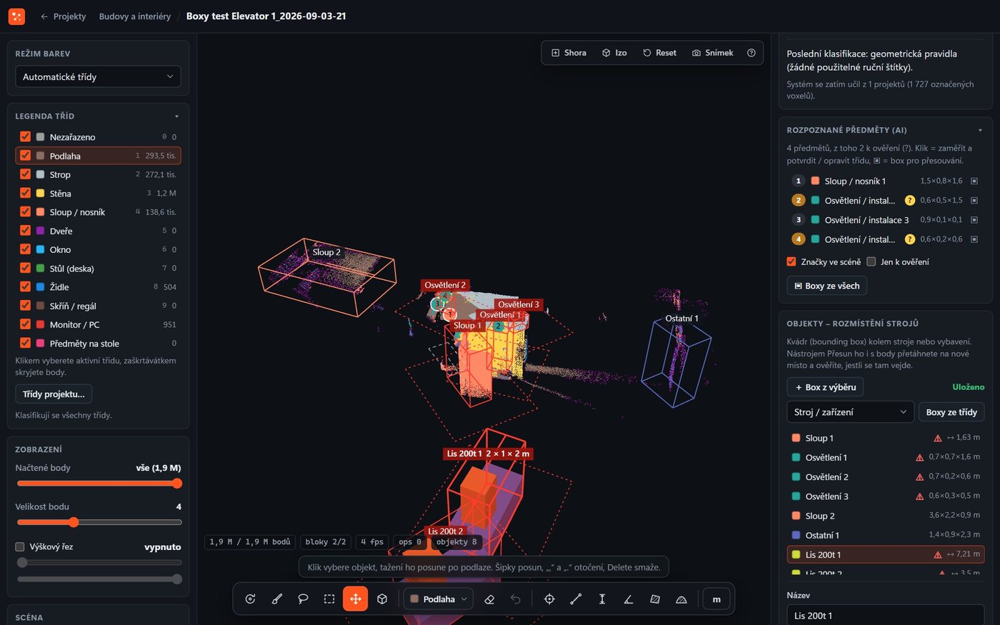
Building point cloud sorted into classes; machines and equipment as boxes with clearance and collision checks.
The workflow is simple: import, optionally add a few manual examples, run the classification. Geometric rules and a base building model find structures, doors, windows and building services even without manual labels.
Floor, ceiling, wall, column / beam, door, window, table, chair, cabinet / shelving, monitor / PC, objects on desk, lighting / services, machine / equipment, noise and other.
Up to 15 custom classes, such as “Press” or “Conveyor”, each with its own colour. Presets: Office, Production hall or Structure only.
Label a few examples and the system finds them elsewhere too — in this project and in your company's other projects. A learned object never overwrites floors, ceilings and walls.
Pitched roofs, columns, struts and beams. A plausibility check reverts physically impossible doors, windows or tables.
A vision model (operated in the EU) names objects in snapshots of the point cloud and projects them back into 3D, with dimensions. Uncertain ones are flagged “to verify”.
Accuracy of the automatic classification against your manual labels: IoU by class, overall accuracy and a confusion matrix.
A box is created from a cluster of points, a selection or an AI-detected object — up to 24 objects per project. Move and rotate the box together with its points (5 cm steps, 5° rotation increments); the original point cloud stays unchanged.
The app checks collisions with fixed points and other objects, and clearances from walls and columns, while you drag. Export the new layout to CSV with the original and new coordinates, dimensions and rotation.
Place IFC models up to 400 MB in the point cloud at the IFC coordinates or on the floor, and check their collisions and clearances just like boxes.
Classified LAZ (manual labels take priority over automatic classification) and E57 in which each class is a separate scan — for standard point cloud, CAD and BIM software. CSV of layouts and measurements.
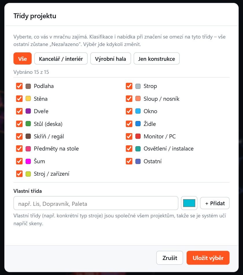
Project classes: choose what to classify in the point cloud and add custom classes for specific machines.
of building points classified correctly without a single manual label. The model was always tested on a scan it had not seen during training.
You can measure accuracy on your own data too: the app compares the automatic classification with your manual labels and shows a confusion matrix. With manual examples, accuracy increases further.
3DSES Gold dataset — seven terrestrial scans of a school building with hand-labelled ground truth.
Not automatically. It prepares a point cloud split into classes — walls, floors, windows, doors, equipment — which makes modelling in BIM software much easier, and it can place finished IFC models in the point cloud. The modelling itself takes place in your BIM tool.
From handheld, terrestrial and mobile scanners in LAS, LAZ, E57 and PLY formats, with files up to 20 GB. E57 files load with all scans and their positions.
No. Structures, doors, windows and building services are found without manual labels. A few manual examples increase accuracy, and the system remembers them for your company's other projects.
Yes — the Production hall preset, custom classes for specific machines and boxes with collision and clearance checks let you plan machine layouts directly in the as-built point cloud of the hall.
Yes: distances, height differences, slopes, angles, horizontal, inclined and vertical areas, and volumes. You can also measure the true area of a curved surface in 3D (a curved facade, roof or terrain) and subtract windows and doors; measure a full cylinder or dome in parts. Export measurements to CSV, in metric or imperial units.
Projects, results and training are shared only within your company. Data and processing run in the cloud in the EU (Scaleway, Warsaw).
Every tree with height, DBH, crown and volume, volume per hectare and a stand map.
Forest inventory →Power line protection zones, railway clearance gauges, road slopes and road asset inventory.
Corridors and mapping →Textured 3D model, orthophoto and DSM from drone photos with an accuracy report.
Drone photogrammetry →All four modules, storage-based plans and verified accuracy in one place.
4CAD PointLab →We offer 3D scanning services in the Czech Republic, Slovakia, Poland, Austria and Germany. We come on site, capture the data you need and use PointLab to prepare the output you need — a classified point cloud, a floor plan, a forest inventory, a power line inventory or a drone model. No need to buy a scanner or software.
Tell us the location, scope and output you need — we'll get back to you within 24–48 hours. More about the service on our As-built building surveys page.
We will be happy to advise you and call you back.
Leave us your contact details and our sales representative will get in touch as soon as possible to explain everything in detail.
PointLab is free for all users until 30 November 2026 — a trial period before the official launch. The plans below apply from 1 December 2026.
All plans include all four modules. The plan sets the storage for uploaded data and the number of users; additional users can be purchased.
As a guide: 1 GB of LAZ corresponds to roughly 25–40 million points, a 20-minute handheld scan takes 0.5–1.5 GB and a drone scan of one hectare of forest 0.2–0.5 GB. Tell us what data you work with and we'll prepare a quote.
Create your account and upload your own point cloud or drone photos. Want to go through the results with us? Book a demo.
Lukáš Tisoň · 3D scanner sales · +420 735 084 982 · lukas.tison@4-cad.cz
Don't have your own scanner? We'll scan it for you — Czech Republic, Slovakia, Poland, Austria, Germany