

3D scanning in construction is no longer a niche reserved for large infrastructure projects. In Czech practice it is quickly becoming the standard wherever you need to capture the actual condition of a building accurately, prepare data for a renovation or convert reality into BIM.
Summary
- 3D scanning in construction delivers the most value for renovations, building documentation, quality control and scan-to-BIM, because it quickly captures the actual condition as a point cloud that can be converted into CAD or an as-built BIM model.
- NIST and Autodesk both state that laser scanning addresses the weakness of older records: design documentation often does not match what was actually built.
- Typical outputs are point clouds, 2D drawings, 3D models and BIM data; in practice they are used in Revit, AutoCAD, Archicad and other systems.
- The biggest difference from manual measurement is that a scanner captures the whole space, not just a few selected dimensions, which reduces repeat site visits, errors and clashes in the design.
- If a building contains reserved technical equipment under the Czech Act No. 250/2021 Coll., 3D scanning also helps with building documentation and records for facility management, but on its own it does not replace statutory inspections, local operating safety regulations or operating documentation.
The value of 3D scanning therefore does not lie in the measurement itself. The real value comes when the data is used for decision-making, coordinating trades, building management or creating an as-built BIM model.
What is 3D scanning in construction and why does it matter today?
3D scanning in construction captures the actual condition of a building with LiDAR and stores it as a point cloud. NIST and Autodesk describe how this data can be used to create an as-built BIM model that tends to be more accurate than data derived only from the original documentation.
This is especially important for older buildings, technical facilities and renovations. Design drawings often do not reflect reality, because changes were made during construction that never made it accurately into the documentation. NIST has long pointed out this problem: BIM derived only from CAD drawings may not capture how the building was actually built.
In practice, 3D scanning is used as a reality capture method. The scanner captures walls, ceilings, building services, openings, pipework and structural elements and creates a dense point cloud. From it you can take dimensions, prepare drawings, model building services or compare the building with the design.
"From 3D scanning, 4CAD solution delivers point clouds, 2D drawings, 3D models and BIM data compatible with Revit, AutoCAD and Archicad."
A common misconception is that a scan automatically means a finished BIM model. In fact, the point cloud is the data foundation. The model, element classification and documentation only come from further processing, depending on the purpose of the project.
When does 3D scanning pay off more than manual measurement?
3D scanning pays off more than manual measurement when you need to capture the whole space, not just a few dimensions. For renovations, plant rooms and complex interiors, LiDAR is comparably fast on site and far more reliable in its output.
Manual measurement still has its place. For a simple room, a single opening or a quick check, a tape measure, a laser distance meter and photos may be the fastest option. But as soon as a project involves several trades, complicated geometry or repeated questions about the data, the advantage shifts to scanning.
The difference lies mainly in the scope of the data. Manual measurement gives you selected dimensions. A scanner captures the whole space, including details you do not need today but may need next week. That reduces repeat site visits. Practical tip: if you already suspect at the briefing stage that HVAC, electrical and pipework clashes will need to be resolved, manual measurement tends to be riskier than it first seems.
The second aspect is safety and time on site. Autodesk points out that scan-to-BIM can reduce the time people spend in demanding construction or industrial environments. If a space is hard to access, dusty or busy with operations, every hour saved on site counts.
What are the 10 uses of 3D scanning in construction?
The most common uses of 3D scanning in construction revolve around the actual condition, coordination and control. MDPI, Autodesk and 4CAD all state that the greatest benefit comes where the data feeds into BIM, design or building management.
In practice, these scenarios come up again and again:
- Surveying existing buildings for renovation
- Documenting buildings and building services
- Creating as-built BIM models
- Scan-to-BIM for architects and design engineers
- Coordinating trades and detecting clashes
- Checking construction quality against the design
- Monitoring construction progress
- Documenting historic and listed buildings
- Data for facility management and site management
- Accurate outputs for 2D drawings, sections and elevations
Each of these uses has different accuracy requirements, a different scope of modelling and a different output format. If you only need to verify geometry, a point cloud may be enough. If a renovation design follows, a 3D model or BIM is usually more suitable.
How does a building survey with a 3D scanner work, step by step?
A building survey with a 3D scanner usually has three steps: preparation, data capture and processing. ScienceDirect describes a similar logic for creating as-built BIM from laser scanning.
Step 1 is defining the goal and scope. First you determine what the result should be: building documentation, data for a renovation, BIM or quality control. That determines the scan density, accuracy, extent of the building and whether only the structure or also the building services will be captured.
Step 2 is the actual data capture on site. In construction, SLAM LiDAR scanners are now often used, such as the FJD Trion P2, S2 or Geomate GS60, which allow you to move quickly through the building. On some projects, multiple stations, photographs and survey control points are combined. A common misconception is that the faster the walk-through, the better the result. In reality, what counts is a well-planned route, the connection between spaces and checking for blind spots.
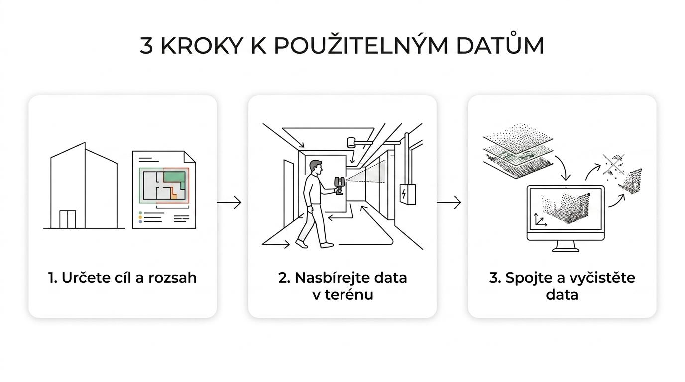
"According to 4CAD, scanning a standard building typically takes 1 day, larger buildings 2 to 3 days."
Step 3 is registration and data cleaning. The point clouds are merged into a single coordinate system, artefacts are removed and the data is prepared for further work. Only then does it make sense to move on to drawings, a model or export to BIM tools.
How is a scan-to-BIM model created from a point cloud?
Scan-to-BIM converts a point cloud into a BIM model with elements that are meaningful for design and management. Autodesk and ScienceDirect describe three basic phases: data capture, point cloud pre-processing and modelling.
In the first phase, a high-quality point cloud is created. If the data has gaps, poor registration or too much noise, the BIM model will be weak regardless of the modeller's skills. That is why it is good to know already during scanning whether walls, ceilings, openings, load-bearing elements or building services will be important.
In the second phase, the data is prepared. Artefacts are filtered out, coordinates are unified and the building is divided into logical parts. ScienceDirect considers this part to be key, because manual work with point clouds tends to be time-consuming and error-prone.
In the third phase, the modelling takes place. The result is an as-built BIM, a model of what was actually built, not an idealised design. If the goal is an architectural study, a simpler level of detail is often enough. If the model feeds into trade coordination or asset management, you need to define in advance which elements should be classified and which attributes they should carry.
Practical tip: do not try to model everything. A clearly defined BIM purpose is more useful than a huge model that nobody uses afterwards.
What outputs do you get from 3D scanning and how do they differ?
There is no single output from 3D scanning. 4CAD routinely works with point clouds, 2D drawings, 3D models and BIM data, and each format solves a different task.
The difference between the outputs is practical, not just technical. A point cloud is the most faithful record of reality, but it is not always convenient for everyday design work. 2D drawings are easy to read and quick to use for the building authority or individual trades. A 3D model suits design and coordination. BIM adds structure, parameters and a link to data management.
Typical outputs can be distinguished as follows:
- Point cloud: the most accurate digital record of the actual condition
- 2D drawings: floor plans, sections, elevations and dimensions for the design or building documentation
- 3D model: a spatial model without the need for full BIM
- As-built BIM: a model with element semantics and data for further workflows
- CAD/BIM exports: integration with Revit, AutoCAD, Archicad and other systems
If you work in a wider digital workflow, it makes sense to think about the link to other tools right from the start. Techcad.cz focuses precisely on connecting CAD data with engineering design, automation and downstream production or documentation.
How does 3D scanning help with renovations and trade coordination?
In renovations, 3D scanning is most valuable where the actual condition differs from the drawings. Revit and Archicad then work with more accurate data, so there are fewer clashes between the structure, HVAC, building services and electrical installations.
Renovation is a typical field where old records are not enough. Load-bearing walls have different thicknesses, beams are offset, services run off-axis and ceilings are uneven. If you only discover these deviations during installation, the project gets more expensive.
Here the 3D scan acts as a shared frame of reference. The architect, the building services engineer and the construction team all see the same data. When a model is created on top of the point cloud, it is easier to design new routes, check penetrations and prepare prefabricated elements. Autodesk describes a similar principle for large steel structures, where data accuracy affects the assembly itself.
A common misconception is that a scan is just a more expensive form of survey. In reality, it is a tool for reducing uncertainty across the entire project.
How can 3D scanning be used for building documentation and facility management?
3D scanning is very well suited to building documentation, because it quickly creates an accurate picture of the building and its technical equipment. In facility management it is also directly linked to the documentation of reserved technical equipment and the obligations under the Czech Act No. 250/2021 Coll.
Today, building documentation is often about more than drawing walls and rooms. Facility managers need an overview of switchboards, boiler rooms, distribution systems, HVAC plant rooms, pressure vessels, gas installations and lifting equipment. If a building contains even a single item of reserved technical equipment, the operator has statutory obligations regarding documentation and safe operation.
"For building documentation, 4CAD solution uses FJD Trion P2 and S2 Series handheld LiDAR scanners, which is practical for surveying buildings and operating areas quickly."
A scan on its own does not replace an inspection or the manufacturer's documentation. But it helps create a reliable basis for locating equipment, verifying where it is and preparing data for a documentation audit. If the manufacturer's documentation in Czech is missing, a local operating safety regulation has to be drawn up. If both are missing, the inspection technician will not approve the equipment as safe to operate.
In practice, these steps have proven effective:
- Responsible person: appoint a person responsible for operating the equipment and managing its documentation
- Building documentation: survey the building, the equipment and its location
- Documentation audit: track down manuals, inspections, tests and maintenance records
- Local operating safety regulation: have one drawn up if the manufacturer's documentation is missing
- Statutory inspections: arrange inspections by authorised persons and remedy defects without undue delay
- Archiving: keep operating documentation and schedules for future inspections
For leased buildings, also keep an eye on Section 20(6), under which responsibility for the proper use and operation of the equipment may pass to the tenant from the day of verifiable handover, if the operator is not the owner.
How is a 3D scan used to check construction quality against the design?
For quality control, a 3D scan is used as a reference measurement of what was actually built. MDPI lists quality assessment as one of the main applications of laser scanning in construction.
Step 1 is defining the element to be checked. This may be a reinforced concrete structure, steelwork, a facade, process equipment or a services route. Without a clear tolerance, the check can easily turn into an endless comparison of everything with everything.
Step 2 is comparing reality with the design. The point cloud or model is overlaid on the design and deviations are tracked. If they exceed the permissible tolerance, you have to decide whether it is an installation error, a design change or an acceptable deviation.
Step 3 is deciding on the impact. If a deviation affects downstream trades, it is dealt with immediately. If it has no effect on safety, function or assembly, it can simply be documented. Practical tip: quality control makes sense on an ongoing basis, not only after the whole building is finished.
How to choose between a SLAM LiDAR scanner and a static laser scanner?
SLAM LiDAR scanners such as the FJD Trion P2, S2 or Geomate GS60 are fast for moving through a building. Static laser scanners tend to be more suitable where very high accuracy at individual stations is the priority and slower work is less of an issue.
The choice depends on the type of building. For routine building documentation, interiors, plant floors and large facilities, SLAM is often more efficient. The operator moves through the space and quickly captures an entire floor or building. This is a strong advantage especially where speed and limited time on site matter.
A static scanner makes sense for a detailed facade, a listed building, precise structural geometry or wherever tightly controlled metrology is required. Sometimes a combination of both approaches is best. A common misconception is that one type of scanner will handle every situation. In reality, it is a trade-off between speed, accuracy, mobility and the downstream workflow.
In construction practice, it is also worth keeping an eye on software and follow-up services. Hardware alone is not enough if the data cannot be brought sensibly into Revit, AutoCAD or a model-sharing environment.
What mistakes do companies most often make when introducing 3D scanning?
The most common mistake is not technical, but in the brief. A company orders a 3D scan without knowing exactly whether it wants a point cloud, drawings, a 3D model or an as-built BIM.
Further problems follow from that. The data may be of high quality, but there is no definition of accuracy, scope or format. The designer expects BIM, the investor wants building documentation and the construction team needs only a few dimensions. The result is unnecessary rework.
It pays to watch out for these points in particular:
- Unclear purpose: without a defined use, both the cost and the risk of a wrong output increase
- Underestimated scope: unscanned plant rooms are what the project misses most
- Confusing a scan with BIM: a point cloud is not a finished information model
- Missing tolerances: in quality control it is then unclear what counts as a defect
- Weak link to CAD/BIM: the data exists, but the team cannot use it
If you answer three questions at the start, most problems disappear: what exactly needs to be captured, what output you need and who will work with the data afterwards. That is where it is decided whether 3D scanning will be just a one-off measurement or a genuinely useful basis for design, construction and building management.


