
Cart (
0
)
No items found.
Go to pricingProduct is not available in this quantity.
PointLab turns an airborne, drone or mobile scan of a corridor into what asset managers need: vegetation encroaching on the power line protection zone, the railway clearance gauge, road slopes and vertical clearances, and an inventory of poles, street lights and signs. Large areas are processed in tiles.
Free for everyone until 30 November 2026 — a trial period before the official launch.
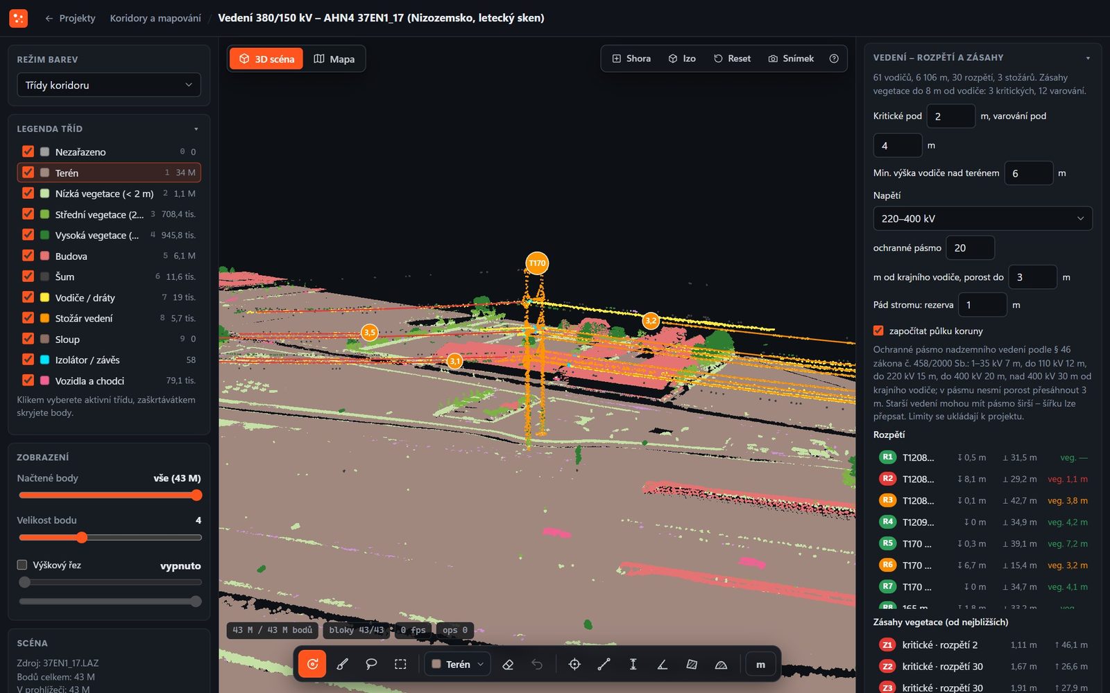
380/150 kV power line: conductors, towers and vegetation. On the right, spans with sag and vegetation encroachments sorted by severity. Data: AHN4 (Netherlands), CC0.
The point cloud produces conductors as curves and, for each span, a list of places where vegetation or a building came closer than allowed.
Span length, conductor sag and minimum height above ground. Towers with position, height and tilt.
Point-by-point distance of vegetation and buildings from the conductors, encroachments sorted into critical and warning. You set the limits.
The zone by voltage under Czech Act No. 458/2000 Coll. and the permitted vegetation height within the zone.
Trees whose branches encroach, that stand close, could fall on the line or grow in the zone — with a fall margin and half the crown.
Rails and track centreline with chainage, clearance gauge infringements and trackside vegetation. Platforms with edge and height.
Mast offset from the track centreline, its tilt and the contact wire height.
Road edges and width, cross slope and longitudinal slope every 2 m and low points for drainage.
Vertical clearance under bridges and gantries, road markings, guardrails, signs and vegetation above the roadway.
Street inventory: poles and street lights with position, height and tilt, traffic signs, railway signals, traffic lights, guardrails, bollards and street furniture; paved and unpaved surfaces, trees with height and crown, and buildings with footprints. In the point cloud you can also measure the area of a curved surface in 3D, such as a curved facade or roof, and subtract windows and doors.
Airborne laser scanning is classified according to ASPRS — terrain, vegetation at three heights, buildings, power lines and vehicles. The result produces DTM, DSM, nDSM and CHM (canopy height) rasters as well as contour lines.
LAZ with classes and object number, 12 CSV tables with GPS (objects, spans, towers, encroachments, clearance gauge, trackside vegetation, slopes, vertical clearance, signs, guardrails, trees, buildings), DXF and GeoJSON vectors by layer, ESRI ASCII Grid rasters, contour lines and E57.
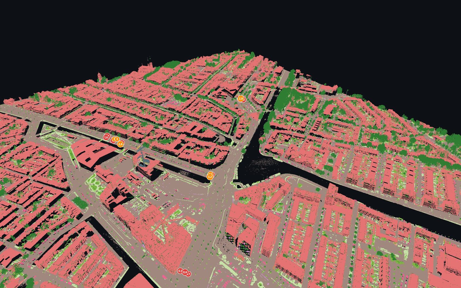
Delft city centre from an airborne scan: buildings, vegetation and terrain. Data: AHN4 (Netherlands), CC0.
These figures are test results on a public airborne scan with official classification, not estimates. On your data, they vary with the scan type and point density.
precision of conductor points on 380/150 kV power lines (recall 82–83%)
terrain agreement in the power line corridor (IoU)
building agreement with the reference in a city centre (IoU)
terrain agreement in a city centre (IoU)
AHN4 dataset — airborne laser scanning of the Netherlands with official classification (380/150 kV power line and Delft city centre).
From airborne and drone scans (sparse data) as well as mobile and terrestrial scans (dense data) in LAS, LAZ, E57 and PLY formats, with files up to 20 GB. Large areas are processed in tiles.
By the line voltage under Czech Act No. 458/2000 Coll. You choose the voltage and the limits for critical encroachments and warnings; the app shows vegetation and buildings that encroach on the zone, as well as the permitted vegetation height.
Yes, as technical data: position, height and tilt of poles and street lights, traffic signs, guardrails, street furniture, road widths and slopes. It is not an official output of surveying activities under Czech Act No. 200/1994 Coll.
The optional AI object check removes false detections, such as a shrub recognised as a car. Remove any remaining errors with the eraser, and the system learns from manual labels for later analyses.
In the project's coordinate system, including S-JTSK; GeoJSON in WGS84. Server exports are in metres; LAZ and E57 keep the coordinates of the source file.
Data and processing run in the cloud in the EU (Scaleway, Warsaw). Only your company can see your projects and results.
Every tree with height, DBH, crown and volume, volume per hectare and a stand map.
Forest inventory →Building point cloud classification for scan to BIM, machine layouts and IFC models.
Buildings and interiors →Textured 3D model, orthophoto and DSM from drone photos with an accuracy report.
Drone photogrammetry →All four modules, storage-based plans and verified accuracy in one place.
4CAD PointLab →We offer 3D scanning services in the Czech Republic, Slovakia, Poland, Austria and Germany. We come on site, capture the data you need and use PointLab to prepare the output you need — a classified point cloud, a floor plan, a forest inventory, a power line inventory or a drone model. No need to buy a scanner or software.
Tell us the location, scope and output you need — we'll get back to you within 24–48 hours. More about the service on our Power line and road mapping page.
We will be happy to advise you and call you back.
Leave us your contact details and our sales representative will get in touch as soon as possible to explain everything in detail.
PointLab is free for all users until 30 November 2026 — a trial period before the official launch. The plans below apply from 1 December 2026.
All plans include all four modules. The plan sets the storage for uploaded data and the number of users; additional users can be purchased.
As a guide: 1 GB of LAZ corresponds to roughly 25–40 million points, a 20-minute handheld scan takes 0.5–1.5 GB and a drone scan of one hectare of forest 0.2–0.5 GB. Tell us what data you work with and we'll prepare a quote.
Create your account and upload your own point cloud or drone photos. Want to go through the results with us? Book a demo.
Lukáš Tisoň · 3D scanner sales · +420 735 084 982 · lukas.tison@4-cad.cz
Don't have your own scanner? We'll scan it for you — Czech Republic, Slovakia, Poland, Austria, Germany